
Product description
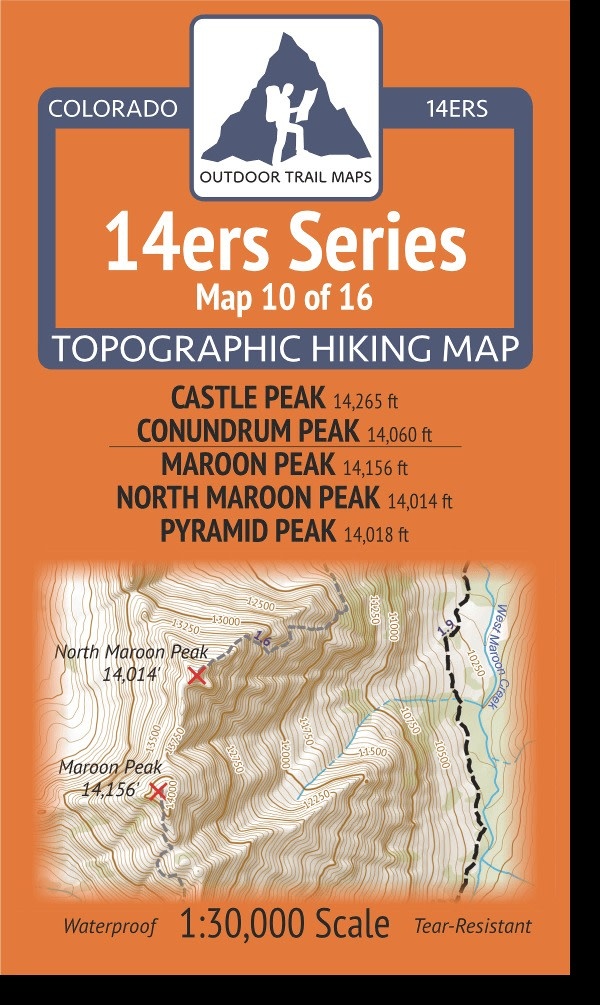
14ers Series Topographic Hiking Map 10 of 16 covers fourteeners Castle Peak and Conundrum Peak on the front side and Maroon Peak, North Maroon Peak and Pyramid Peak on the back, including all hiking trails in the surrounding areas. This rugged trail map was designed for on-trail use in the toughest outdoor conditions and includes the following features:
- Waterproof and tear-resistant paper
- Ultralight weight – under an ounce
- Detailed 1:30,000 scale (1 inch ≈ ½ mile)
- Distances for all trail segments
- Compact folded size to fit in your pocket – only 3.8” wide by 6.5” tall
- Convenient size and foldability for quick and easy on-trail review – 19” wide by 13” tall unfolded – no more fumbling with huge maps while on the go
- All fourteener trailheads – not just the popular ones – with GPS coordinates
- GPS coordinates for all key trail junctions
- Route difficulty classes for each peak
- UTM 1000 m grid along with latitude-longitude ticks
- Easy-to-read and intuitive
In addition to the fourteener hikes to Castle and Conundrum Peaks via the 4WD roads from Castle Creek on the front of 14ers Map 10, there is full coverage of the American Lake Trail, the Cathedral Lake Trail and Cathedral Lake area, and the Electric Pass Trail.
The back of Map 10 shows the entire West Maroon Pass Trail from Maroon Lake Trailhead in the north to the East Fork Trailhead in the south via West Maroon Pass, along with the Crater Lake area, the Hasley Basin Trail and Fravert Basin area, Frigid Air Pass and the North Fork Trail. This is Map 10 of 16 14ers Maps covering all Colorado 14ers.
Recently Viewed
Outdoor Trail Maps
Outdoor Trail Maps 14ers Series Map 10/16 Castle, Conundrum | Maroon North Maroon Pyramid
$5.95
Suncloud Optics
Suncloud Optics Domain Matte Black Polarized Low Light Rose Sunglasses
$79.95

Hydro Flask
Hydro Flask Wide Mouth Bottle with Flex Sip Lid 20oz
$34.95
Outdoor Trail Maps
Outdoor Trail Maps 14ers Series Map 08/16 Princeton | Yale
$5.95